Go to: OVERVIEW
(SaveOurCounty) DETAILS
(listener)
PLANNING SCHOOLS ENVIRONMENT EROSION
Report corrections & broken links to Webmaster Get updates on local issues
TABLE OF CONTENTS . . click for LOCATION MAP
BRECKENRIDGE EAST, A Residential Subdivision Jefferson County, West Virginia
COMMUNITY IMPACT STATEMENT June 18, 2003
1. General Description of the Project Pages 1 - 8
2. Relationship to the Community -- Physical, Social and Economic Impacts Pages 8 - 17
Exhibit "A" Gen. Loc. Map
Exhibit "A.1" Tract Map
Exhibit "B" Concept Feas. Plan
Exhibit "C" USGS Soil Survey Map
Exhibit "D" Hist. Property Letter
Exhibit "E" Prop. Coy. & Restrict.
Exhibit "F" Market Survey
Exhibit "G" Div. of Nat. Res. Letter
Exhibit "H" Jeff. Co. Health Dept. Letter
Exhibit "I" State Health Dept. Letter
Exhibit "J" Wetlands, ponds Map
Exhibit "K" N.R.C.S. Map
Exhibit "K"[sic] Hillis-Carnes Engin. Letter
Exhibit "L"Jeff. Co. Bd. Of Educ. Letter
Exhibit "M"Transportation Report
Exhibit "N"Jeff. Co. Mem. Hosp. Letter
Exhibit "O"Ind. Fire & Rescue Co. Letter
Exhibit "P"Jeff. Co. Sheriff Letter
Exhibit "Q"W V State Police Letter
Exhibit "R"Waste Mgmnt. Letter
Exhibit "S"Electric Service Note
Exhibit"T"Frontier Comm. Letter
Exhibit "U"Jeff. Utilities Letter
Exhibit "V"Jeff. Co. PSD Letter
BRECKENRIDGE EAST A Residential Subdivision Jefferson County, West Virginia
COMMUNITY IMPACT STATEMENT June 18, 2003
A. General Description of the Project
1. Name, Address and Telephone Number of Owner/Developer
Mr. Jerry Connelly, VP
B.C. Partners, Inc.
24012 Frederick Road
Clarksburg, MD 20871-9718
301-428-0500
2. Name, Address and Telephone Number of Contact Person
Mr. Mike Schmidt, P.E., Associate
Project Manager
Loiederman Soltesz Associates, Inc.
7 North Market Street, Suite 300
Frederick, MD 21701
301-696-1240
3. Tract Size, Shape, Location and Zoning
The project is generally located north of Flowing Springs Run and east of Country Club Road, also known as WVA Route 24. The subject tract size is approximately 415.94 acres and is part of the overall 855 acre Breckenridge development. The zoning is "Residential - Growth District".
(Please refer to General Location Map, Exhibit "A")
|
Tax District Name |
Map # |
Parcel# |
Area acres |
Deed Ref. |
Remarks |
|
Harpers Ferry |
10 |
2 |
99.21 |
850/470 |
1 |
5.Number, Approximate Size and Location of Proposed Lots or Building Sites
The subject project consists of 694 single4amily lots. The approximate areas and widths are as follows:
•The lot areas will range from 10,000 sq. ft. to over 20,000 sq. ft.
•The lot widths will range from a minimum of 85 ft.(approx. 74%) to over 100 ft. ft. and the largest lot will be (approx. 26%). The smallest lot will be 10,000 sq. ft. and the largest lot will be approximately 50,000 sq. ft.
The residential project is designed so that the particular lot sizes and locations compliment abutting land uses, with regard to use and density, both internal and external to the development.
6.General Description of Surface Conditions (Topography)
The area proposed for development is moderately sloped at about 1 to 10 percent, includes several rock outcroppings and areas of cropland. A ridgeline, ranging in elevation from 430 to 500 MSL runs generally northeast from a mid-point of the westerly property line (along Country Club Road), through the sub-station to the western property line. The ridgeline effectively defines the major drainage divide. The ridgeline grade gradually descends to the northwest to a seasonally wet drainage way and southeastward to minor swales. Two minor "saddles" exist along the ridgeline. The site includes isolated wooded areas, all of which have been preserved in the Concept Feasibility Plan for wildlife habitat and aesthetic appeal for future residents. The neighboring properties include moderate slopes.
7.Soil and Drainage Characteristics
a. Soils are shown on Sheets 9 and 10 of the Soil Survey of Jefferson County, West Virginia, issued February 1973 (Please refer to the attached Soil Survey, ExhIbit "C"). The on-site soils are listed as:
DgB Duffield silt loam,2 to 6 percent slopes
Dg C Duffleid silt loam,6 to 12 percent slopes
Dg C3 Duffield silt loam,6 to 12 percent slopes, severely eroded
FbB Frankstown shaly silt loam,2 to 6 percent slopes
FbC Frankstown shaly silt loam,6 to 12 percent slopes
FbC3 Frankstown shaly silt loam,6 to 12 percent slopes, severely eroded
FbD3 Frankstown shaly silt loam,12 to 25 percent slopes, severely eroded loam
FcD3 Frankstown very rocky silt loam 12 to 25 percent slopes, severely eroded
Hf B Hagerstown and Frederick cherty silt barns, 2 to 6 percent slopes
HfC Hagerstown and Frederick cherty silt loam 6 to 12 percent slopes
HhC3 Hagerstown and Frederick cherty silty clay barns, 6 to 12 percent slopes
Ho Huntington silt loam, local alluvium
Lo Lindside silt loam, local alluvium
There are five (5) primary soil types on the development: the Ouffield, Frankstown, Hagerstown and Frederick, Huntington and Lindside series. These soils are deep, well drained soils, which were formed in material weathered mainly from limestone, silty limestone, limy shales, and alluvium washed from limestone uplands. Construction limitations are generally slight to moderate, except in lower-lying areas of the Lindside series, where limitations can be severe.
b. The project drains to two major drainage basins: the Shenandoah and the Potomac. There is a total of five (5) on-site sub-drainage sheds, with four (4) draining in a north-to south direction directly to Flowing Springs Run, which is tributary to the Shenandoah River, and the fifth draining in a south-to-north direction to an unnamed tributary of Elks Run, which is tributary to Elk Branch, which is tributary to the Potomac River.
The owner/developer will provide stormwater management (SWM) in accordance with County criteria, and for all development areas draining in these sub-drainage sheds. The SWM facilities will provide quantity controls to pre-development runoff rates, and water quality controls via extended detention or artificial wetland treatment methods. As required, the SWM designs will review safety measures to minimize adverse impacts to downstream property.
c. Erosion and sediment controls (stone entrances, earth dikes, sediment traps, silt fences, etc.) and phased and limited site grading, will be implemented during site construction to minimize soil losses and for erosion.
Portions of the Breckenridge East property were previously utilized as apple
orchards. The application of pesticides associated with this prior agricultural
use has resulted in elevated arsenic levels within some of the surface soils in
these areas. The developer is committed to working with the West Virginia
Department of Environmental Protection on an appropriate remediation plan to
address this issue.
8. Existing Natural or Man Made Features including Vegetative Cover, Water Bodies, Quarries and Rock Outcroppings
During the past several years, approximately 65 % of the property has been cropland. The fencerows and a small number of isolated wooded areas include various ages of tree growth and scrub brush. The geology is Elbrook Formation, which is argillaceous, dolomitic limestone with beds of dolomite and algal limestone. There are several limestone outcroppings. The property does not include a quarry or any natural water bodies.
Exclusive of the structures discussed below (#9), the balance of the property includes an overhead power line that runs in a north-south direction and a related sub-station. A gravel drive runs from Country Club Road to the existing on-site substation. Another driveway servicing a vacant and vandalized home runs from Rt. 230 to the home, generally located along the eastern property line.
A 1988 Sink Hole Inventory Map from the Natural Resource Conservation Service is attached as Exhibit "K" and depicts a sinkhole located towards the southwest corner of the property. A letter from a geotechnical engineer HilIis - Carnes, Inc. is attached as ExhibIt "K-1" and further concludes, by way of field-checking the subject area, that the sinkhole identified on the 1988 Sink Hole Inventory Map does not exist.
9. General Location of Existing Structures
A driveway and vacant house are located toward the eastern side of the property. The heavily vandalized two-story building is approximately 20 ft. high, includes an iSft x 25ft. footprint, with a majority of the building composed of a fairly recent addition, completed in the late 1950's~or early 60's. A small number of abandoned and declining accessory structures are located near the house. As the house and accessory buildings are either extensively vandalized and/or in significant decline, the owner/developer considers them as a liability and plan to raze them in the near future. Please note that none of the aforementioned structures are considered historically significant, as confirmed by the attached letter from the West Virginia Division of Culture and History, Exhibit "D". Lastly, the property includes a centrally located metal storage building and an Allegheny Power sub-station building that rebates to an overhead power line.
10. General Location and Description of Existing Easements or Rights-of-Way
An Allegheny Power, Inc. right-of-way easement currently traverses the property in a north-south manner. A power substation, owned and maintained by Allegheny Power, Inc. is located along the aforementioned easement. A driveway easement, for the use of Allegheny Power to access the sub-station traverses the property from Country Club Road to the sub-station. The driveway easement will overlay the final street layout so as assure continued access for Allegheny Power. The easement and substation are depicted on the Concept Feasibility Plan and the design of the development considered their locations. Various other minor easements, generally associated with undeveloped land, traverse or abut the property, and will be incorporated, properly relocated or extinguished as the design phase proceeds.
11. Existing Covenants and Restrictions
There are no existing covenants and restrictions on the subject property.
12. Approximate size, location and purpose of areas to be dedicated
The owner/developer intends to create and dedicate the following areas
(please refer to the Concept Feasibility Plan) to the Home Owners Association
(HOA):
Purpose Approx. Size Location
Pool, bathhouse, tot lots, tennis courts 2.84 ac. As depicted
Soccer, softball and practice fields 11 .46 ac. As depicted
"Pocket" Parks and Landscaped Areas 49.05 ac. As depicted
Stormwater Mgmt. Areas 11.93 ac. As depicted
Please note that the HOA will assess the future residents as necessary to
provide sufficient funds appropriate to operate, maintain and set aside
replacement reserves for the dedicated areas.
13. Intended Improvements
As depicted on the Concept Feasibility Plan (Exhibit "B"), the project will include the necessary public roads, utilities, stormwater management facilities, and recreation and open space areas to support an attractive and viable residential Community. To facilitate vehicle flow, the roadway network includes a "spine" or central road from which branch smaller, lower volume roads. The network disperses traffic by providing a variety of pedestrian and vehicular routes to homes, common areas and destinations outside of the Community. For example, a hiker-biker trail set back along the "spine road" is proposed to promote pedestrian and cyclist use of the central road for exercise and access to neighborhoods and common areas. Earthen berms will be placed periodically along its common property line with homesites to provide visual interest for passers-by and vehicle buffering for the residents. Partial medians were placed at many points along the "spine road" to encourage slower vehicle speeds. Slower vehicles allow for an environment more suitable for pedestrians and bicycles. The use of cul-de-sacs also promotes a greater sense of community within the many neighborhoods.
The paved roadways will be open section, and will be designed to direct storm-water to water management facilities, while also maximizing infiltration within the swales.
The project will include a pool and bathhouse, tennis court, and a Community Park that proposes a soccer field, softball field, practice field, tot lot and a multi-age playground. Approximately ninety parking spaces are planned for the Community Park. To further increase open space, and to encourage pedestrian use, "pocket" parks are located in convenient areas throughout the project for passive recreation.
14. Intended Land Uses
The project will include 694 single-family homes. The approximate areas and widths are as follows:
•The lot areas will range from 10,000 sq. ft. to over 20,000 sq. ft.
•The lot widths will range from a minimum of 85 ft. (approx.74%) to over 100 ft. (approx. 26%)
The improvements (sheds, pools, etc.) associated with the homes will be similar to those in the area.
Other land uses include a pool and bathhouse, tennis courts, and a Community Park that proposes a soccer field, softball field, practice field, tot lot and a multi-age playground. To further increase open space, and to encourage pedestrian use, "pocket" parks are located in convenient areas throughout the project for passive recreation.
15. Intended Earthwork that would alter the Natural Topography
The site design for the Concept Feasibility Plan of homesites, common areas and
roadways occurred only after the careful review and consideration of the existing terrain, its natural contours and its relationship to neighboring properties and abutting roadways. The roadways, as one may note from the Concept Feasibility Plan, are proposed in areas that align with the contours of the land, and result in a minimal amount of cutting and filling of the natural topography. Improvements that will require grading beyond the natural topography amount to less than 10 percent of the overall site. Grading will be conducted as necessary for the installation of the spine road, sewer and water services, and to facilitate stormwater management. Time and time again, the owner/developer has witnessed that working with the existing characteristics of the land results in greater appeal to the eventual residents, the environment, and the economics of a proposal.
16. Proposed Covenants and Restrictions
A draft of the proposed Covenants and Restrictions are attached herewith as Exhibit "E". Additionally, in an effort to facilitate water service for Sam Michael's P ark and Harpers Ferry Job Corp. Jefferson Utilities has requested that the owner/developer grant an easement to Jefferson Utilities this year for a future water transmission line along the north side of the proposed extension of Breckenridge Way.
17. Tentative Development and Construction Schedule
Following the approval of the final plat, the project's development and seven-year home construction schedule is as follows:
Initiate site development: Summer 2004
Phase 1 = 99 lots Phase 5 = 99 lots
Phase 2 = 99 lots Phase 6 = 99 lots
Phase 3 = 99 lots Phase 7 = 100 lots
Phase 4 = 99 lots
18. Market Surveys and Feasibility Studies
Please refer to the enclosed Market Survey, prepared by Pitheon Marketing Productions, LLC, dated April 2003, Exhibit "F".
19. Anticipated Project Costs
The preliminary site construction cost estimate for the project is:
Roads (includes SWM, electric and telephone): $8,397,400
Water system:, $2,748,240
Sewer system: $4,122,360
Total $15,268,000
20. Anticipated Funding Sources
The funding will be provided by loans from private lending institutions.
B. Relationship to the Community - Physical, Social and Economic Impacts
1. Earthwork
As typically required, a degree of earthwork will be necessary for the construction of the roads, infrastructure, stormwater management facilities and building pads. The earthwork operation will occur in phases, a mass stripping of the property will be avoided, and cuts and fills are expected to balance. It is anticipated that some blasting will be required as the utility lines are installed. A small number of the natural drainage ways may be altered, but this will not result in a negative impact to neighbors or to the future residents of the Community. Suitable measures will be taken during construction to ensure proper management of soil and erosion issues. The stormwater management facilities will be constructed in accordance with current regulations. As depicted on the Concept Feasibility Plan, Exhibit B, an effort has been made to retain the isolated wooded areas and the existing wooded fencerows.
2. Conversion of Farm Land to Urban Uses
Historically, a relatively small portion of the property was orchard, but several years ago the property was converted to cropland and included the propagation of soybeans, alfalfa, green beans, and corn. During the last three years, approximately 65 percent of the property has been used for agricultural purposes. More recently, the crop operation has been scaled back. The current owner/developer is not involved in the farming or orchard business and plans to convert all of the agricultural property, over a period of seven years, for use in the proposed development. As previously noted, focusing growth into growth areas/boundaries is a nationally recognized "smart growth" implementation tool to preserve agricultural resources.
3. Wildlife populations and Endangered Species
The land area of the proposed Community is inhabited by species typical to Jefferson County. Those species include whitetail deer, skunks, raccoons, opossums, groundhogs, squirrels, foxes and turkeys. There are no known rare or endangered species of wildlife indigenous to the area of the proposed development. As required during the CIS process, an inquiry was made to the West Virginia Division of Natural Resources for an evaluation. A copy of theirletter stating that they have no record of endangered species existing on the property is included in the Appendix as Exhibit "G". Please note that the proposed development intends to occupy the same area that the pre-existing cropland operation occupied, hence resulting in no net loss of habitat.
4. Groundwater and Surface Water
Due to the following, it is anticipated that the quality of the post-development conditions of the groundwater and surface water will meet or exceed the existing pre-development conditions:
•Public water and public sanitary sewer will service the development's potable water and sewage needs.
•The stormwater will be managed and treated with a combination of grass-lined swales along roadways and several stormwater management facilities located throughout the project site.
The local and State Health Department were asked to confirm that there are no reported water contamination problems within 1000 feet of the proposed subdivision. A letter from the Jefferson County Health Department is attached as Exhibit "H". A letter from The State Health Department (Exhibit "I") states that there are no public wells within 1000 ft. of the proposed subdivision. Suitable measures will be taken during construction to ensure proper management of soil and erosion issues.
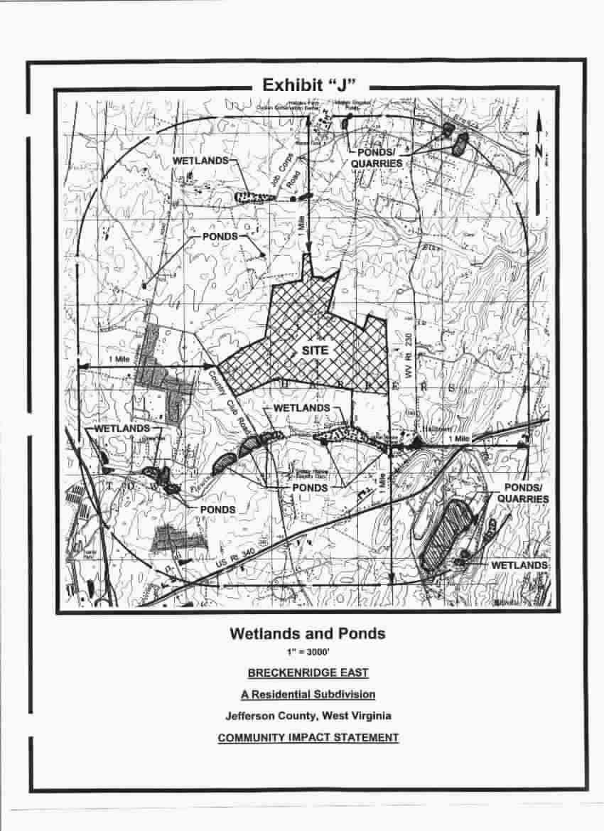
A location map depicting the wetlands, ponds and marshes within one mile of the site is attached as Exhibit "J". No negative impact on the aforementioned areas is expected. area
5. Compatibility of the Project In Terms of Land Use
The construction of residential housing in this area is in accordance with the Comprehensive Plan and the Residential-Growth Zoning District in the Zoning Regulations. A great degree of effort has been placed in preparing the Concept Feasibility Plan. The primary point of ingress/egress is located at a higher elevation on Country Club Road provides maximum visibility for vehicles and adequate distance from other abutting ingress/egress points along Country Club Road. The proposed "spine" or central road will tie into, and become part of the existing Breckenridge Way to the north. Vehicle and pedestrian access to the Community Park and Community Area land uses are proposed along the "spine" road to facilitate ingress/egress with low impact to abutting Breckenridge East residents. Two existing and compatible residential developments, Breckenridge Phase I and Breckenridge North abut to the west and north, respectively. A compatible residential development. The Community of Beallair, is proposed to the south of the subject development. The Sleepy Hollow Country Club golf course also abuts the southwesterly property line. Farmland and two homesteads within the County's Residential-Growth Zoning District, abut to the northwest and east of the subject development. The Concept Feasibility Plan also recognizes and retains many of the existing forested areas and tree lines for visual and natural interest. Specifically, many of the existing hedgerows and wooded areas have been preserved along property lines and outside homesite building pads. Furthermore, and though not required per Section 4.11 of the Zoning and Development Review Ordinance, green space buffering is proposed to the rear of homesites that abut off-site land uses that are different or potentially commercial in nature, such as the abutting Sleepy Hollow Golf Course and the commercially zoned property at the southeast corner of the project.
6. Impact on Sensitive Natural Areas
A 1988 Sink Hole Inventory Map from the Natural Resource Conservation Service is attached as Exhibit "K" and depicts a sinkhole located towards the southwest corner of the property. There is no evidence of the sinkhole at this time, or in recent memory of the farmer who attended to the land. Mr. Mark Kozar of the USGS stated that many times, the farmer would simply fill the smaller holes in with rock and sand and the sink would not reappear. A letter from a geotechnical engineer Hillis -- Cames, Inc. is attached as Exhibit "K-I" and further concludes, by way of field-checking the subject area, that the sinkhole identified on the 1988 Sink Hole Inventory Map does not exist. Considering this fact and combined with the absence of standing water bodies, it is concluded that this project will not affect water recharge. A number of the natural drainage ways may be altered, but this will not result in a negative impact to neighbors or to the future residents of the Community. Suitable measures will be taken during construction to ensure proper management of soil and erosion issues. Please note that all stormwater facilities will manage and treat the stormwater before releasing it into natural drainage ways. There are no streams on-site or within 500 feet of the stormwater discharge point. The conditions of the areas within 500 feet of the stormwater discharge outfall include existing swales and are adequate to accommodate the discharge. As stated earlier, it is anticipated that the quality of the post-development conditions of the surface water will meet or exceed the existing pre-development conditions.
7. Demand on Schools
Based upon 694 single-family homesites and the Jefferson County Public School Standards (Table 50, Section III-71, Jefferson County Comprehensive Plan) this subdivision calculates the number of children by utilizing the following factors: 0.27 for elementary school, 0.12 for junior high school and 0.11 for high school and results in the following: [way outdated & way low]
Elementary: 188 pupils
Junior H.S.: 84 pupils
High School: 77 pupils
Based upon 694 single-family homesites and census data, this subdivision calculates the number of children by utilizing the following factors: 0.35 for elementary school, 0.16 for junior high school and 0.11 for high school and results in the following:
Elementary: 243 pupils
Junior H.S.: 111 pupils
High School: 77 pupils
The Community will be served by the following schools and includes projections for 2002-2003 enrollments:
i. T.A. Lowery Elementary School
Capacity of School: 447 Children
2002-2003 School Enrollment: 547 Children
ii. Charles Town Junior High School
Capacity of School: 742 Children
2002-2003 School Enrollment: 835 Children
iii. Jefferson County High School
Capacity of School: 1349 Children
2002-2003 School Enrollment: 1664 Children
Per the requirements of the CIS, the owner/developer, B.C. Partners, provided the projected enrollments for the above elementary, junior and high schools. However, please note that the owner/developer is aware that discussions regarding enrollment formulas, capacity and funding are currently underway between the Jefferson County Board of Education and the Jefferson County government. While the discussions continue, B.C. Partners would like to underscore its support of equitable impact fees and a belief that development should pay its fair share toward public school improvements. Toward that end, on June 13, 2003, B. C. Partners presented a proposal to the Jefferson County Board of Education to provide a site for a new elementary school. The donation is at no cost or obligation, now or in the future, to the Board of Education or to the Jefferson County government. In addition to the donation, B.C. Partners will include site engineering services and the processing of the subdivision application at no cost to the Jefferson County Board of Education or to the Jefferson County government. With a long standing relationship in Jefferson County, B.C. Partners, Inc. desires to continue its goodwill and contribute to the future of education in Jefferson County. The letter to the Board of Education is included as Exhibit "L".
8. Transportation Impact Data
The project will generate vehicle traffic associated with a residential development. The project will enjoy two points of access. The primary access ties into Country Club Road at the western property line and is planned and designed to accommodate the majority of vehicles. The secondary access point is northward to Job Corps Road.
The key intersections associated with this development are:
• Breckenridge Way, the proposed primary ingress/egress, and Country Club Road
• Country Club Road and Flowing Springs Road
• Breckenridge Way and Job Corps Road
• Country Club Road and Posting Way (North)
• Country Club Road and Posting Way (South)
Kellerco, Inc., professional transportation engineers, conducted a comprehensive traffic study to determine any potential impacts from the proposed development. This study utilized actual field traffic counts recorded by Kellerco personnel as well as projected WV State Highway traffic growth rates for the area.
The Study concludes that very acceptable Levels of Service (A and B) are achieved at all intersections associated with the development. Please refer to the attached Traffic Study, dated March 27, 2003, prepared by Kellerco, as Exhibit "M".
It should also be noted that a signal has been installed by the West Virginia Division of Highways at the intersection of Rt. 340 and Country Club Road. This signal will allow for the safe and proficient [sic] movement of traffic from Country Club Road onto Rt. 340.
As requested by the County on the CIS checklist, one "Highway Problem Area", per Map 3 of the 1994 Comprehensive Plan, has been identified as near the Community and is labeled as an "unmarked curve" on Job Corps Road. Per Mr. Larry Deets of the West Virginia Division of Highways, three (3) curved-arrow signs were placed in January 2003 to address this issue and warn drivers of the curve.
The most current available ADT count (2002 count by the West Virginia Division of Highways) for the Average Daily Traffic Count for Country Club Road was 2500.
9. Demographic Impact
Table 24, page 26, in Section II of the Comprehensive Plan represents that 400 to 500 homes per year are needed to satisfy the demand of the growing population. It is anticipated that Breckenridge East will generate approximately 99 units per year, and will be constructed and sold over a total project sales life of seven years. Considering the aforementioned, it can be concluded that Breckenridge East will satisfy only a portion of the overall demand for housing in Jefferson County.
The ultimate resident population, after a project life of seven years, is estimated to be 1,666 (694 x 2.4 per household, per census data) persons.
10. Health and Emergency Services
The Jefferson Memorial Hospital is located approximately 3.5 miles from the project and includes the closest and highest concentration of medical practitioners. The Jefferson Memorial Hospital confirms (refer to Exhibit "N") that the hospital is prepared to provide health and emergency services. The Independent Fire and Rescue facilities are located in Ranson, just a few miles west of the project. The Harpers Ferry Fire and Rescue also provides coverage for this area, and is located approximately 3.5 miles northeast of the project. Assistant Chief Scott Biller of the Harpers Ferry Fire and Rescue stated that they would provide "material aid" (back-up) for Independent Fire and Rescue. Please refer to ExhIbit "0" confirming emergency and fire service coverage from the Independent Fire and Rescue Company.
11. Fire Protection
The Independent Fire and Rescue facilities are located in Ranson, just a few miles west of the project. The Harpers Ferry Fire and Rescue also provides coverage for this area, and is located approximately 3.5 miles northeast of the project. Assistant Chief Scott Biller of the Harpers Ferry Fire and Rescue stated that they would provide "material aid" (back-up) for Independent Fire and Rescue. Please refer to Exhibit "0" confirming emergency and fire service coverage from the Independent Fire and Rescue Company.
12. Police Protection
Police service and protection will be provided by the Jefferson County Sheriffs office, with reinforcement from the West Virginia State Police. Please refer to Exhibit "P" from the Jefferson County Sheriff's office confirming police service and protection coverage. The West Virginia State Police have confirmed that the proposed community is in their service area. Please refer to Exhibit "Q". The project area is not serviced by the Charles Town Police Department.
13. Trash Removal
Waste Management, Inc. will provide trash removal service. Please refer to Exhibit "R".
14. Electric Service
Allegheny Power, Inc. will provide electric service. Please refer to Exhibit "S".
15. Telephone Service
Frontier (A Citizens Communication Company) will provide telephone service. Please refer to Exhibit "T".
16. Sewer and Water Service
The Jefferson County Public Service District (PSD) has agreed to provide sanitary sewer service. Ultimately, sewage will flow to a proposed interceptor abutting Flowing Springs Run, to the south of the Community. In the interim however, and prior to the completion of the interceptor, sewage may be directed to the existing Breckenridge pump station, or possibly to an interim sewage treatment facility being considered for the Halltown vicinity.
Jefferson Utilities, Inc. has agreed to provide water service. The water service main is anticipated to run along the proposed "spine" road and loop from Breckenridge North to Breckenridge Phase 1. The public utility service providers will become owners and provide maintenance for all the respective facilities after the owner/developer has installed the water and sewer service. The height of the water tower is 672 ft. (elevation at overflow). Please refer to the letter from Jefferson Utilities, Inc. dated February 29, 2003 and Exhibit "U", confirming availability of water service coverage. A letter from the Jefferson County Public Service District (PSD) dated July 8, 2002, Exhibit "V", states that they will provide service to the Community. The owner/developer continues to work with the PSD to analyze and implement solutions, both short and long term, addressing the future capacity needs of the county.
17. Relationship of the Project to the Comprehensive Plan
The owner/developer believes that the proposed development is consistent with the goals and recommendations of the Jefferson County Comprehensive Plan:
Relative to Use:
"To continue encouraging new residential developments to be located so as to maximize the use of existing public facilities and service investments such as schools, parks, sewer and water", (Page 109, Jefferson County Comprehensive Plan). Public water and sewer will service the development, and a public elementary school site and a Community Park are proposed.
Relative to Area:
"New Development should be encouraged to be located near existing or planned public services and should be designed for higher density to preserve open land", (Page 106, Jefferson County Comprehensive Plan). The area of the proposed Community includes significant water, sewer and roadway capacity capable of accommodating additional development. Secondly, on June 3 , the owner/developer, B.C. Partners, presented a proposal to the Jefferson County School Board to provide a site for a new elementary school. The dpnation is at no cost or obligation, now or in the future to the School Board or to the Jefferson County government. With a long standing relationship in Jefferson County, B.C. Partners, Inc. desires to continue its goodwill and contribute to the future of education in Jefferson County.
18. Housing Supply and Demand
The Market Survey, prepared by Pitheon Marketing Productions, LLC, states that between 1997 and 2002, residential sales activity increased 60% as average sales prices grew 47%. Towards satisfying the increase in demand, the report concludes that the Breckenridge East Community, with its extensive and attractive amenities, will absorb the homes over approximately a seven-year period. Secondly, Section III, Residential Land Use, page 109, Item 10 of the Jefferson County Comprehensive Plan states that there is a shortage of acceptable housing and anticipates this shortage to continue into the future.
19. Proximity to Known Historic Features
The West Virginia Division of Culture and History has stated that the subject property and areas within 500 ft. do not include any structures or features of historical significance (Exhibit "0").
Per the West Virginia Division of Culture and History, two properties, the Beall-Air Farm and the Media Farm are respectively, 1500 ft and 6000 ft from our property line. The Beau-Air Farm property (abutting to the south of us) was recently approved to consist of 299 homes and includes renovation of the existing homestead as a community center. There are no known pre-colonial Native American features on the subject property. There are no known human burial sites on the subject property.
In addition to the above-mentioned structures, the "Windshield Survey on Explorer: The West Virginia History Database, Jefferson County Module" by Dr. William D. Theriault, includes the "Walnut Grove" homestead. The Walnut Grove homestead is approximately 2500 ft. from the entrance to Breckenridge East.
As noted earlier in the report, a driveway and vacant house are located toward the eastern side of the property. The heavily vandalized two-story building is approximately 20 ft. high, includes an I 8ft x 25ft. footprint, with a majority of the building composed of a fairly recent addition, completed in the late 1950's or early 60's. A small number of abandoned and declining accessory structures are located near the house. As the house and accessory buildings are either extensively vandalized and/or in significant decline, the owner/developer considers them as a liability and plan to raze them in the near future. Please note that none of the aforementioned structures are considered historically significant, as confirmed by the attached letter from the West Virginia Division of Culture and History, Exhibit "D".
20. Recreation
The project will include a pool and bathhouse, tennis court, and a Community Park that consists of a soccer field, softball field, practice field, tot lot and a multi-age playground. To further increase open space, and to encourage pedestrian use, '1pocket" parks are located in convenient areas throughout the project for passive recreation.
The nearest Municipal Parks: Liberty Street Park, Charles Town, 2.5 miles Ranson Park and Playground, Ranson, 2.5 miles
The nearest County Parks: Jefferson County Community Center, 3.0 miles Potomac Edison Park (Harper's Ferry), 3.0 miles Sam Michaels Park, less than 0.5 miles
The State and Federal Parks: within two miles: Shannondale Springs, a state-owned potential park (per Section III-74-B, Table 5.1 Comprehensive Plan)
21. Property Tax Evaluation
It is estimated that the development will generate (yearly) income for the Jefferson County Government in residential taxes based on the following:
Jefferson Co. Real Property Tax Guide, Class II Rates
Appraised Value of Project: $156,150,000 ($225,000 x 694)
Assessed Value (60% of above value): $93,690,000
Total County Tax Rate: 1.2142 / $100 (2002)
Tax Computation: $1,137,583.90
22. Anticipated Bank Deposits
It is anticipated that the compensation for labor and materials associated with the site development and home construction within the Breckenridge East Community will include the use of the nearby banks. The residents of the Community are expected to utilize the local banks for checking, savings and lending.
23. Anticipate Local Spending
It is anticipated that the site development and home construction associated with the Breckenridge East Community will draw upon the local and nearby areas for materials and labor. In fact, a majority of the contractors hired to develop the abutting Breckenridge North and Breckenridge developments are local Jefferson County businesses. We expect this trend to continue. Lastly, and with greater and longer lasting impact, it is anticipated that the residents of the Community will conduct their daily spending in the area's shopping, commercial and medical centers.
24. Local Employment Implications
It is anticipated that the local employment demand will increase over-time as more people move into the Community and seek or require local services and locally produced goods. Additionally, as the population of Jefferson County increases, it is expected that the employment centers will grow and attract local residents to work locally.
25. Expected Changes in Property Values
During the last 25 years, the owner/developer has witnessed property values increase in all of their residential projects in the area. The necessary ingredients of proper site selection, a well thought-out land plan, attractive and high quality construction, and a greater degree of landscape, open space and on-site recreational opportunities have contributed to a positive and sustained impact for all of the communities developed by the owner/developer. Considering this history of increased values of the owner/developer's projects, it is anticipated that the adjoining properties will only benefit from the development of the Breckenridge East Community.
June 5, 2003
WEST VIRGINIA DIVISION OF CULTURE AND HISTORY
Mr. Jonathan Soule
BC Partners, Inc.
24024 Frederick Road
Clarksburg, MD 20871
RE: Breckenridge LSA No.: 0064-22-00
FR#: 03-469-JF-2
Dear Mr. Soule:
We have reviewed the above mentioned project to determine its effects to cultural resource and submit our comments.
Architectural Resources:
Thank you for submitting additional information regarding your project. We have determined that the proposed project will have no effect on any property eligible for or listed in the National Register of Historic Places. Therefore. no further consultation is necessary with this office regarding architectural resources.
Archaeological Resources:
We understand that no federal monies, permits, or licences are necessary for completion of your project and, as such, Section 106 of the National Historic Preservation Act of 1966 does not apply. As our maps indicate that no known archaeological resources are located within your parcel, state laws governing cultural resources also do not apply. In the event that either situation changes we ask that you contact this office for guidance.
We appreciate the opportunity to be of service. If you have questions regarding our comments, please call Robin Fisher, Historian or me at (304) 558-0240.
Sincerely,
Joanna Wilson
Senior Archaeologist
JLW:rlf
THE CULTURAL CENTER • 1900 KANAWHA BOULEVARD, EAST CHARLESTON, WEST VIRGINIA 25305-0300
TELEPHONE 304-558-0220 • FAX 304-558-2779 • TDD 304-558-3562
EEO/AA EMPLOYER
DIVISION OF NATURAL RESOURCES Wildlife Resources Section Operations Center
P.O. Box 67 Elkins, West Virginia 26241-3235 Telephone (304) 637-0245 Fax (304) 637-0250
Bob Wise Governor, Ed Hamrick Director
April 1,2003
Mr. Michael J. Schmidt
Loiederman Soltesz Associates
7 N. Market Street, Suite 300
Frederick, MD 21701
Dear Mr. Schmidt:
We have reviewed our files for information on rare, threatened and endangered (RTE) species and wetlands for the area of the proposed Breckenridge development in Charles Town, Jefferson County, WV (LSA No. 0064-22-00).
We have no known records of any RTE species or wetlands within the project area. The Wildlife Resources Section knows of no surveys that have been conducted in the area for rare species or rare species habitat. Consequently, this response is based on information currently available and should not be considered a comprehensive survey of the area under review.
Thank you for your inquiry, and should you have any questions please feel free to call upon us.
Sincerely,
Barbara Sargent
Environmental Resources Specialist, Wildlife Diversity Program,
JEFFERSON Memorial Hospital
March 25, 2003
Michael J. Schmidt, P.E.
Loiderman Soltesz Associates
7N. Mark Street
Suite 300
Frederick, Maryland 21701
Dear Mr. Schmidt:
This letter is in response to your letter of March 13, 2003, concerning the development of a 695-unit single-family development to be part of the Breckenridge Development.
Jefferson Memorial Hospital will be pleased to provide medical/hospital services to the residents in this community. As you are aware, there are numerous projects under development in Jefferson County. In order to be prepared for this future development, Jefferson Memorial Hospital is currently developing a Master Facility Plan. As part of this planning process, we are evaluating the possibility of relocating the Hospital to a new location. Areas being considered are located within one to two miles of our present location in Ranson. Therefore, it should be well positioned to care for the residents of the Breckenridge area.
Please let me know if you need any additional information at this time.
Sincerely,
John M. Sherwood, FACHE
Chief Executive Officer
JMS:lsr
300 S. Preston Street • Ranson, WV 25438 (304) 728-1600 • (304) 725-9492 Fax www.jeffmem.com
INDEPENDENT FIRE CO., INC.
LOCATION: FAIRFAX BLVD. & SECOND AVE. RANSON, WV 25438
ORGANIZED 1884
AMBULANCE FIRE RESCUE
MAILING ADDRESS: P.O. BOX 925 CHARLES TOWN WV 25414
STRICTLY VOLUNTEER
March 25, 2003
Michael J. Schmidt, P.E.
Loiederman Soltesz Associates
7 N. Market Street
Frederick, MD 21701
Re: Breckenridge LSA No: 0064-22-00
Dear Mr. Schmidt:
Our Fire Company is committed to providing high quality service to the residence of our response area. We are however having problems with manpower and the significant increases in responses within our area of coverage.
The proposed addition of 695 units of single family residence will cause additional strain on our resources. As the EMS and Fire Service providers for 125 square miles of Jefferson County, we are seeing a 10 percent plus growth each year and feel that these additional homes can do nothing but increase this problem. Without supplement funding or resources, we will be unable to provide the quality and timeliness that is required for the services to which we are committed.
I can be reached at 304 725-2514 if additional information or questions arise.
Edwin D. Smith
Fire Chief
Jefferson County Public Service District 210 W. 3rd Avenue Ranson, WV 25438
Phone: 304-725-4647 Fax: 3o4-725-5976
E-mail: jcpsd@stargate.net
July 8, 2002
Jefferson County Planning Commission
Mr. Paul Raco, Director
104 East Washington Street
Charles Town, WV 25414
Dear Paul:
This letter will serve to confirm that the Jefferson County Public Service District is in the process of evaluating sewage collection for the proposed development by BC Partners. The Subdivision is Breckenridge, Section II, a 1,000 lot subdivision located in Jefferson County. There will be a new alternate mainline extension agreement that will replace the previous agreement.
Our process consists of the following steps:
A.) Our engineer will determine a cost to extend our collection line to the project within 45 days. That information will be presented to the Developer. The Developer can then deposit the amount calculated by our engineer with the District and the District will undertake the construction of the facilities necessary to provide service, or, the Developer can elect to construct the collection and transmission facilities according to the District's requirements and, when such construction is completed, turn it over to the District.
B.) If the Developer elects to construct the system rather than have the District do the work, our Attorney will prepare a draft of a document that is referred to as an "alternate mainline extension agreement" between the Developer and the Jefferson County PSD.
C.) Once that agreement is approved by the Developer and the Jefferson County PSD Board, the agreement will be sent to the Public Service Commission in Charleston for final approval.
D.)The Public Service District requires all developers to provide title insurance policies for all lines within easements that will be dedicated to the District.
E.) At the completion of the project the District requires that you provide on a CD, a set of drawings in DXF format for use on future GIS (Geographical Information Systems) systems. If DXF format is not available, CAD format will be acceptable.
It is the District's understanding that, when fully built out, the project will have approximately 1000 units.
As a utility subject to the Public Service Commission's Rules and Regulations, the District has an obligation to extend service upon request where such extension is economically feasible. However, it is important to understand that the District cannot reserve capacity to serve customers. If the District was to guarantee that it would have capacity to serve all of the projected development in an area, it could lead to the District incurring totally unnecessary expense to build capacity that may never be used. Witness the fact that there have been numerous development proposals in the past that have never been constructed, or, because of changes in economic conditions, projects have been scaled back.
Thus, the entry into the alternate main extension agreement with the Developer does not mean that the District will reserve capacity to serve all 1,000 units. Rather, the agreement is intended to recognize that, as the Developer's system is built out, and as other developments are built out, the District will have to determine whether it is necessary to expand its capacity in order to meet the future growth on its system. If it is ultimately deemed necessary to expand its capacity in order for the District provide service, it will endeavor to obtain the necessary funds to extend service to meet those needs in an economically reasonable fashion.
If any further information is needed please contact this office.
Sincerely,
Susanne Lawton
General Manager